by Sherri on October 20, 2008

This photo of Mount Shasta was taken from the boat launch at Ahjumawi Lava Springs State Park.
Jeff and I were loading up the kayaks for our paddle at Ahjumawi Lava Springs State Park. I looked up and there was Mount Shasta staring at me.
I thought it would be good to capture a closer up view of this beauty, in addition to the wide angle shot in my last post.
by Sherri on October 17, 2008

Mount Shasta, California, as viewed from the dirt road to Ahjumawi Lava Springs State Park.
Jeff and I were really jazzed about finally getting to experience Ahjumawi Lava Springs State Park, in Northeastern Californa. It had been high on our priority list for a couple of years.
The journey getting there was just as enjoyable for us, as getting to the destination itself. That’s usually the case, whenever we travel off-the-beaten path via dirt roads, back roads, or by four wheel drive. In fact, when we are traveling on a dirt road, our dog Cocoa even gets the nickname “Dirt Road Dog,” because she prefers them too. I’m not kidding! She gets very excited as soon as the road turns to dirt, just like we do.
The scenery on the way into Ahjumawi Lava Springs State Park was breathtaking. The photo above was one of our favorite scenes along the way.
Come back soon for photos of Ahjumawi Lava Springs State Park!
by Sherri on October 6, 2008

McArthur-Burney Falls taken from the observation deck at the top.
This is the view you get when you don’t take the hike down to the base of the falls. In some ways, I think this view is more impressive. You get to see the falls in their entirety. That said, I also highly recommend taking the hike, so you can see it from many different perspectives. This is especially important if you are a photographer. [click to continue…]
by Sherri on October 3, 2008

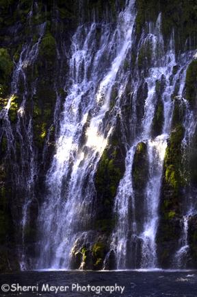
Close up view of McArthur-Burney Falls, California
This is definitely one of the most unique shots of the falls I got and one I’ve never seen before.
I had to climb over very slippery rocks and get sprayed by the mist coming off of the falls to get this shot, but it was worth it.
More to come…
by Sherri on October 1, 2008

McArthur-Burney Falls, Shasta County, California
This shot of McArthur-Burney Falls (also known as Burney Falls to many) I took because I thought it would make a great cover shot. There is plenty of empty space at both the top and the bottom of the photograph for text.
Today, I was originally going to post a close up shot of the falls taken down at the bottom of the trail. But, I decided it needed some work before posting.
I’m going to do a little experimenting with Lightroom 2, our new Photo Management Software to see what I can do to improve it.
Stay tuned. I will be posting a couple more shots of this natural wonder, before moving on to the next place we visited during our road trip.
by Sherri on September 29, 2008

McArthur-Burney Falls, McArthur-Burney Falls Memorial State Park, California
People travel from all over the country to see spectacular McArthur-Burney Falls in Shasta County. But, most of them photograph it from the observation deck at the top.
My goal when we traveled there recently was to capture the falls from many different perspectives. That meant hiking down the fairly short but steep trail to the base of the falls. I was amazed at how different the falls looked once I got to the bottom. I was also amazed at how challenging it was to photograph!
This photo is one of my favorites from the series I shot. Here is another one of my favorites, that I posted during our Northeastern California Road Trip. I will post more photos of it later this week, along with a few tips for a successful photo shoot.
by Sherri on September 23, 2008

Photo #1- Indian Creek in Taylorsville, CA (Plumas County) shot in the morning.
Getting back to our recent road trip photo essay…
One of the great things about staying in one place for awhile is that you have more than one opportunity to photograph a subject. While we were camping along Indian Creek, I had just that kind of opportunity. [click to continue…]
by Sherri on August 26, 2008

Indian Creek, Taylorsville, California shot on Nikon D-300 with Tokina 12-24mm lens.
It’s a lot easier to Blog about our Northeastern California Road Trip, now that we are home and with power. [click to continue…]
by Sherri on August 24, 2008

View of Fallen Leaf Lake and Lake Tahoe, from the Mt. Tallac Trail, South Lake Tahoe, California
Our final destination during our road trip was Fallen Leaf Lake Campground, in South Lake Tahoe, California. We live less than 2 hours away from the most popular lake in the country (also known as “Lake in the sky”), but we usually avoid it because of the crowds.
[click to continue…]
by Sherri on August 16, 2008

McArthur-Burney Falls Memorial State Park, Shasta County, California.
Greetings from the road everyone,
We apologize for the long gaps between posts, but Blogging from the road has been very challenging. We have set up camp in 3 different locations since leaving home, all without power. To download our images to our laptop, we are using a power inverter that converts battery power to AC power. For checking our e-mail and posting to our Photo Blog, we have to drive to the nearest town, which has been as far away as 35-miles (today in Alturas). Boy, have we learned a lot on this trip! [click to continue…]