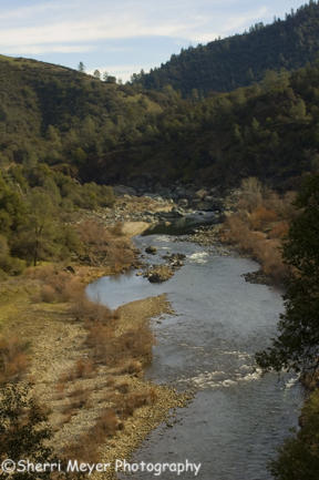
Middle Fork of the American River, Auburn, CA
This photo was taken on the same day the waterfall photo was taken. We were hiking on the right side of the river on the Western States Trail in El Dorado County. Had we been hiking on the other side of the river, we would have been hiking in Placer County.Â
The Western States Trail is the trail that connects Auburn to Squaw Valley in Lake Tahoe and is used for annual endurance races such as the Western States 100 and the Tevis Cup.
But, endurance participants are not the only ones using this trail! It is also very popular for hiking, mountain biking, running, swimming, horseback riding, gold prospecting and picnicking.
You can choose to hike in one-mile to a nice picnic area, or you can hike 5.5-miles to what some people refer to as the end of the trail, to another nice picnic area. Beyond this point, the trail narrows and is used mainly by equestrians and endurance runners.
There are also many nice spots along the river for taking a dip, gold prospecting, fishing, picnicking or just simply enjoying the beautiful American River.
There are 3 forks of the American River; the north fork, the middle fork and the south fork. The north and middle forks converge in Auburn, just a couple miles from where this photo was taken. The south fork is south on highway 49 and runs through Coloma. It is the most popular of the 3 for whitewater rafting.
The middle fork where this photo was taken, is the coldest fork of the 2 forks that converge in Auburn. The water in the middle fork comes from the bottom of Oxbow Reservoir and the north fork water flows over the dam at Lake Clementine, therefore is the most popular of the two for swimming in.Â
The Western States Trail is one of many great trails in the Auburn State Recreation Area. For more information on trails in the area and other things to do, visit the Auburn State Recreation Area Website.
I saw the Huell Howser California’s Gold show on Coloma yesterday and it reminded me of how beautiful the American River is. What I appreciate about much of that area is how sparesly developed it is and much of hte natural landscape is still there to explore.
Did you happen to see the series Huell did on finding the exact corners of California? They have been showing them over the last couple of weeks. They will probably show them again, if you missed them. They were very interesting!
Jeff and I watched a bunch of travelogues, while we were sick with the flu.
I havent’ seen that episode tho it sounds cool. I’ve seen his show a few times, I think Half Moon Bay and Death Valley. I used to like watching Bay Area Backroads also when I lived up there.