by Sherri on November 10, 2011

Sherri sitting in Mobius Arch, Alabama Hills, California.
For several days, I haven’t been able to work on my blog at all. After lot’s of trouble shooting and help on Google+, I have concluded that it was issues with Firefox. I am now using Google Chrome and I’m really anxious to see how it’s going to work. So far, so good!
About the photo:
This is from our recent “Eastern Sierra” road trip. You can see more photos on my Facebook Page; also on my Google+ Profile.
Most of the photos you see of this famous arch are void of people, taken at night, early morning etc. We couldn’t be everywhere for the good light and this is one of the locations we had to improvise on. Of course, a polariser was used for this image, otherwise the sky would have “sucked” (I hate that word, but I’m using it anyway!).
The big mountain in the background is Lone Pine Peak and next to it on the right behind the arch is Mount Whitney.
~Sherri
Sherri Meyer Photography
by Sherri on October 26, 2011

Fall colors at Conway Summit, Eastern Sierra, California.
We are back. As there is no such thing as perfect, I will rate this trip a 9 1/2 out of 10. We had a few very minor things go wrong, but that is to be expected!
The image above was captured from the road (highway 395) at Conway Summit. Actually, I shot this from the truck window and this is straight out of the camera. I did not push the color one bit on this one. The color over there was to die for, as it turns out, unlike what we heard before we left home! 🙂
Our shooting wasn’t just about fall color though, as is for many folks traveling through this region this time of the year. We included people in many of our images kayaking, fishing, camping, soaking in hot springs, hiking and more, with the fall colors in the backdrop. We also shot landscapes, nature and abstracts for our Fine Art Collection.
NOTE: If you are planning a trip to the Eastern Sierra to photograph the colorful Aspens in all of their glory, I recommend going within the next week. Their leaves were falling like crazy at the higher elevations, when we were there last week!
Stay tuned for more images from this almost perfect adventure!
Cheers,
Sherri
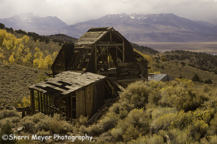
by Sherri on November 14, 2008

Chemung Mine, Bridgeport, California
This holiday season, we are doing something a little different. Starting now and running until the end of December, you can order prints of any photos in our on-line galleries at a special 20% off price. NOTE: The prices you see listed by each photo are the regular prices. The discount will be deducted automatically, during the checkout process.
To take advantage of this “special offer,” please visit our Ordering Information page.
Happy Holidays!
by Sherri on November 9, 2007
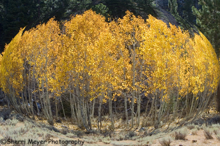
Photo – Abstract Aspen grove, near Bridgeport, CA
This abstract was created from the same original photograph of the Aspen grove I have been featuring over the last few weeks. I used the Spherize Distorting Filter in PhotoShop to get this effect. This doesn’t work well on all subjects, but with a little experimenting, you will find what works best.
Happy experimenting!
by Sherri on November 8, 2007
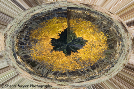
Photo – Abstract Aspen grove near Bridgeport, CA
Although fall has pretty much done it’s thing, I’ve decided that I’m not done creating fall images! Here is a very abstract version of an Aspen grove photo I featured a few weeks back.
by Sherri on October 25, 2007
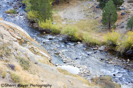
Photo – View of the soaking pools on Buckeye Creek
Here is another shot of Buckeye Hot Spring. This photo shows what the soaking pools actually look like. Posting this makes me want to jump in the car and go there right now!
This wraps up my photo essay on our fall colors trip last October.
by Sherri on October 24, 2007
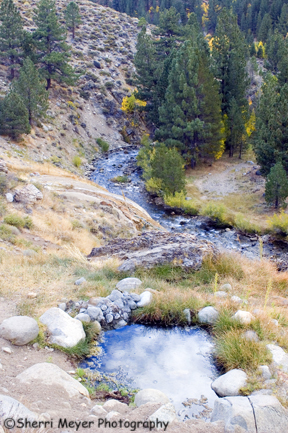
Buckeye Hot Spring, near Bridgeport, California.
This is one of our favorite hot springs in California and a soak here is free! It is located on the creek, clothing is optional and you can often have it all to yourself. Plus, it is a short drive or walk from Buckeye Campground.
The small pool in the foreground is a hot water source. This pool is scalding hot and is not for soaking in. The water flows down the hill from this pool and eventually drops into Buckeye Creek. There it mixes with the creek water and cools down to temperatures suitable for soaking.
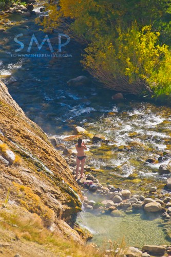
Woman enjoying Buckeye Hot Spring, Eastern Sierra, California. Put this on your “Bucket List!”
If you are going, make sure you take everything you will need with you (towel, snacks, water etc.) and wear good footwear. The walk down to the creek is very steep and slippery in spots and you won’t want to make the trek too many times. If soaking at night, be sure to pack a flashlight also.
Every time we travel scenic highway 395, we make it a priority to visit Buckeye Hot Spring!
Directions – To get to Buckeye from the northern end of Bridgeport, turn off of Route 395, turn west on Twin Lakes Road and travel seven miles. Turn right just past Doc and Al’s Resort, then cross the bridge going over the creek. Continue uphill along a gravel road, past Buckeye Campground. At the top of the hill you’ll find a parking area. The springs are down the trail from the parking lot. Closed in the winter.
by Sherri on October 23, 2007
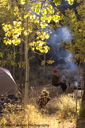
Our camp at Buckeye Campground.
We made base camp at beautiful Buckeye Campground, located along Buckeye Creek in the Toiyabe National Forest. That put us in close proximity to the things we wanted to do and places we wanted to explore.
This turned out to be another one of our favorite camping spots. The camp sites were huge and only a couple of them were occupied when we were there. The fall color was intense, as you can see in this photo. And there were several great hiking trails nearby to choose from. NOTE: There is a fee to camp at Buckeye. There are also free campsites nearby.
by Sherri on October 22, 2007
 Â
Â
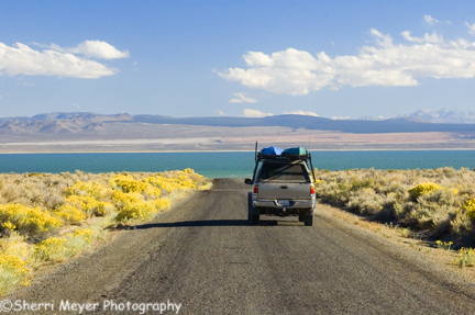
Photo – View of Mono Lake from the Cottonwood Canyon Road
The road we were traveling on turned into the Cottonwood Canyon Road, which eventually led us to Mono Lake.Â
We drove around to the tourist side of the lake, with plans of doing a sunset paddle in our kayaks. We had wanted to do this for a long time. Unfortunately, our timing was off. The winds are fierce in the afternoon. We could hardly get out of the car, let alone do a paddle!
We did a lot of planning and researching for this trip, but we failed to find out when the best times to paddle Mono Lake are. Next time we visit that area, we will paddle at sunrise.
by Sherri on October 21, 2007
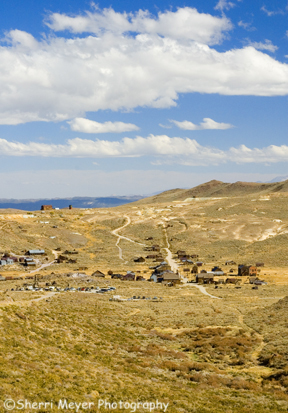
Photo – Bodie State Historical Park, as seen from the Bodie Ghost Town TrailÂ
From the Masonic Trail, we intersected Aurora Canyon Road (also known as the Bodie Ghost Town Trail) and dropped down into Bodie. Â
Bodie, California is located in the eastern slopes of the Sierra, close to the Nevada border and is known as the best preserved ghost town in California. It was once a gold-mining town with 10000 residents way back in 1879.
We will be adding this photo of Bodie, as well as photos taken in the park from our previous trip, to our stock photo galleries soon.
